


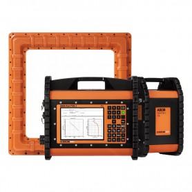
ABEM WalkTEM 2, The World Leading TEM Instrument for Geophysical Investigations
The ABEM WalkTEM 2 is a user-friendly, rapid survey solution that can provide precise resistivity models directly in the field for the search, mapping and monitoring of groundwater, mineral deposits, and environmental change.
Quoted price includes:
- ABEM WalkTEM 2 RX Standard
- ABEM WalkTEM 2 TX-20
- ABEM RC-5 Active receiver coil, 33m lead-in
- ABEM RC-200 Active receiver coil, 33m lead-in
- ABEM TL-1K6 40x40m Transmitter loop, on reel
- TEM 1D processing software (1 perpetual lic.)
Please contact us directly for other configurations.


The ABEM WalkTEM 2 represents the ultimate scalable system that should fit any customer’s survey requirements or budget and a broad range of applications.
Depths of hundreds of metres can be investigated in minutes and the work can be finished whilst other survey methods would still be setting up. The system is scalable, with modular hardware, allowing expansion of the instrument capabilities in line with your changing needs.
What is TEM?
TEM (Transient Electromagnetic) is a geophysical technique used to obtain vertical resistivity soundings and a method which responds most strongly to conductive materials.
The method is non-destructive and uses a series of wire loops for transmitting and receiving signals in the ground so no marks will be left in the survey area after measurements are finished.
The TEM procedure is remarkably efficient: with just a 40×40 meter square transmitter loop and 1 or 2 smaller receiver coils, it is possible to reach depths of 200-250 meters and to get from setting-up to a resistivity model only takes a few minutes. With a suitable system configuration, it is possible to reach depths of more than 800 meters, without a huge increase in survey times.
The TEM method is perfectly suited to locating groundwater and minerals, but also useful for applications such as geological mapping and environmental surveys.
![]()
Typical application areas
Search, map, monitor ...
- Groundwater
- Environmental
- Minerals
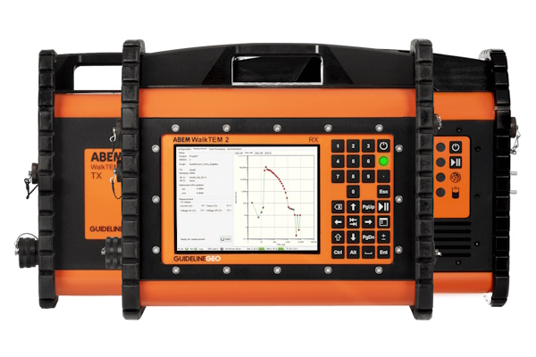
Precise results from superior data qualityEvery aspect of the ABEM WalkTEM 2 has been designed with a focus on optimizing data quality. Clean, precise TEM data is measured seamlessly from shallow to deep thanks to Dual Moment measurements, broad dynamic range, robust ABS polymer housings and separate, yet compact, transmitters and receivers. |
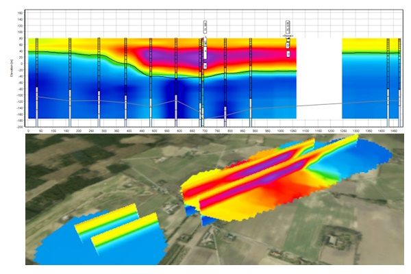
TEM resistivity 1D / 3D |
|
 |
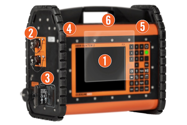
Remote connectivityOperate, upgrade, download or test anywhere, at any time Remote connectivity can allow the ABEM support team to assist with software upgrades, give support or troubleshoot if necessary. This unique feature ensures that the system is always up to date, operating correctly, with the risk of downtime kept to an absolute minimum. The built-in field computer in the ABEM WalkTEM 2 offers robust computing power, an easy to use graphical user interface and connectivity such as USB, Ethernet and Wi-Fi. The internal GPS supports GLONASS, which improves positioning accuracy. Data is stored on a removable 16 GB microSD memory card, with a capacity of millions of data readings. Advantages:
. . |
|
Rapid field survey procedures and analysisWith a focus on efficient operation, it is possible to map in minutes what could take hours or days with other geophysical technologies or drilling. The ABEM WalkTEM 2 combines features such as the unique Dual Moment measurement mode with multiple receiver channels to enable collection of parallel data streams in a single measurement cycle. After data collection is finished the results can be modelled directly on the instrument so that quality assurance measures, and even an initial geological interpretation, can be done without need for a laptop or a return to the office. |
|
|
|
|
A rugged system made for the fieldDesigned and optimized for even the harshest of conditions The robust and durable aluminum casing meets IEC IP66 classification and allows for use in anywhere from -20°C to +70°C. Durable high specification connectors, a 6mm shatterproof glass screen and protective rubber bump strips ensure a reliable and tough system.
|
|
|
|
||
WEBINARS ..Introduction to ABEM WalkTEM 2ABEM Product Manager, Jimmy Adcock, provides an introduction to both the TEM method and the ABEM WalkTEM 2 system and accessories. The TEM (transient electromagnetic) method is perfectly suited to rapidly locating water and minerals, and monitoring environmental change, even hundreds of meters below the surface. The ABEM WalkTEM 2 is an efficient means of generating resistivity models, reliably and easily, with exceptional data quality. The new scalable specifications and modular design provides unique flexibility. |
||
Transient Electromagnetics TEM and the ABEM WalkTEM 2Jimmy Adcock and @CDMSmith presents the ABEM WalkTEM 2 and the TEM method. The ABEM WalkTEM 2 is a user-friendly, rapid survey solution that can provide precise resistivity models directly in the field for the search, mapping and monitoring of groundwater, mineral deposits, and environmental change. A high sensitivity to conductive materials makes TEM extremely useful in groundwater studies, for example differentiating between fresh, brackish and saline deposits, monitoring drawdown and recharge of an aquifer, or simply estimating its extents by building up profiles or grids of soundings. |
||

1. The prices displayed on the site, including special offers, are valid only for the products in stock, within the available limit!
2. Customized products (eg cables cut to the required length) cannot be refunded and cannot be returned!
3. The images of the products presented on the site are for information purposes only and may differ from the real products!
4. Micronix Plus SRL reserves the right to change the prices and specifications of the products without prior notice.


 Camera for Hydrocarbons, ATEX compliant")

